You can no longer see the remnants from the road. But years ago, visitors coming to Kingstree on what is now known as the Sumter Highway were amazed to see 57 acres of what looked like white beach sand, or snow, sparkling off to their left. In fact, many people came to Kingstree just to get a look at what was often described as the "Inland Beach." Residents were for the most part unimpressed. They had always known about the White Sand Hills. It was a phenomenon that had always been there.
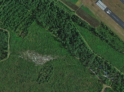
Google maps satellite shows an aerial view of what is left of the
White Sand Hills just west of Kingstree.
Which is not to say that local residents didn't appreciate the White Sand Hills. Back in the 1890s, when James McClary owned the property, he made it available to local groups as a picnic area. On many occasions, young people loaded up wagons and traveled the three or so miles out of town for a moonlight picnic. In September, 1909, after one such picnic, The County Record declared, "The sand hills never looked grander than last night in the light of the beautiful full moon." This went on for many years, as evidenced by another small announcement in the July 17, 1919, issue of the newspaper which mentioned a watermelon party held at the Sand Hills.
One news article, written by Laura C. Hemingway, which appeared in the February 24, 1929, Charlotte Observer, noted that the area had originally contained 200-300 acres and described it as a "typical ocean beach, platter-shaped...with an unknown depth of sand." She added that the sandy area was then three miles in circumference, sloping down to a shallow pond in the center, shaped like a huge fish bed.
All kinds of theories were advanced about its origin. Some said it was the remains of the beach that had existed when the ocean reached all the way inland to Williamsburg County. Others told the fantastic tale of a gigantic sea monster in prehistoric times fashioning this basin for a bed, in which water had later deposited the sand. Still others insisted that this was the original bed for Black River, although most people didn't think the river's course had shifted two-and-a-half miles over the years.
Another small area of sand can be seen through the trees in this satellite view.
The runway of Williamsburg County Airport is in the upper right hand corner.
An article, published December 4, 1927, in the News & Courier, described it like this: "As seen through a vista of moss-draped live oaks as one approaches, one would think that certainly here is a great expanse of snow. There are many holly trees scattered over it, always with berries upon them. The contour is uneven, suggesting the name of Sand Hills. About midway of the several acres composing this, there is a group of live oaks and other vegetation that resembles an outdoor cathedral. This is interesting when we recall the first camp meeting ever held in this state was held there in 1802. Many thousands attended the services which were held almost continuously day and night, some of the most prominent ministers in the state taking part." Laura Hemingway also told of the camp meeting, stating that, "Many are the tales of religious fervor that survive that time."
She describes the sand hills as having lives oaks in the inner section while the outer parts were bare of plant life. She noted that the scrub oaks lining the rim turned bright colors every autumn, and for long weeks held the color of the setting sun like a burning bush circling a mystery spot. She, too, noted that the many holly trees always had berries on them, no matter what season, and the sparkleberries and huckleberries growing there had berries on them long after the season had passed elsewhere.
More remnants of sand seen through the trees from the Google Maps satellite.
By 1925, the property had passed from the McClary family to Cooper Brothers. At that time, the Coastal Highway, then Highway 17, now US52, was under construction. L.D. Rogers had the contract to furnish sand for the hard-surfacing of the road as it neared Kingstree. The sand used was taken from the White Sand Hills. Rogers employed 14 trucks, each hauling an average of 12 loads a day, to take the sand to a mixing plant near the railroad. There, it was mixed with rock and cement, before it was hauled to the causeway where water was added.
Interest in the commercial use of the sand remained after the paving was completed. Scientific analysis showed that it was 99.7 percent pure silica. This high quality of sand should be used in something of greater importance than road paving, it was decided. In 1932, the E.P. Pitts Sand Company of Sumter bought the sand hills from Stuart Cunningham. Pitts leased the old cotton seed oil mill located near the railroad in the vicinity of today's Railroad Auction to serve as a drying plant. The sand was trucked from the sand hills to the plant where it was dried and then sifted into rail cars. Eight, 40-ton carloads of sand were shipped each week. The plant provided jobs for 14 area men during the Depression. Most of the sand was shipped to Laurens, SC, where it was made into glass fruit-jars and bottles. In May, 1932, several of these glass containers made from sand gathered from the Sand Hills were on exhibition in Kingstree.
According to Pitts, the sand was between 12 and 15 feet deep. At 14 to 15 feet, it stopped abruptly at a layer of black muck, which somehow did not contaminate the sand on top of it. Residents were interested that sea shells and prehistoric specimens had been dug up with the sand. The article refers to these specimens as thunderbolts, which could mean stone artifacts such as axes, adzes, or spearpoints, but could also mean stones that had formed as a result of lightning striking the sand. Fossils were also found in rocks extracted from the sand. These rocks, when analyzed, showed high concentrations of phosphate.
The current owners of the property would like everyone to understand that for insurance reasons the general public cannot be permitted access to what is left of the sand hills.


